Wednesday, March 24, 2010
Creating data visualization dashboards with Google Maps API Premier

Monday, February 8, 2010
Enhanced security for Google Maps API Premier
However, any web service can be vulnerable to anonymous automated access. To further protect our Premier customers from unauthorized use of their client IDs, we’re adding an additional layer of security to Google Maps API Premier.
Starting today, we will be issuing a private cryptographic key, unique to each account, to all Maps API Premier customers. From now on, requests made to certain web services from Maps API Premier accounts will need to be “signed” with this key. This security enhancement will ensure that requests are authorized by the owner of the Maps API Premier client ID specified in the request.
Existing Maps API Premier customers should expect to receive an email from Google within the next 10 days containing their private cryptographic key. For documentation explaining how to use this cryptographic key to sign requests, please refer to the Maps API Premier Developer Guide. The Static Maps V2 API is the first API to support URL signing.
As of March 2, 2010, requests made to the Static Maps V2 API will need to be signed to be accepted. However, for added security, we encourage you to begin signing requests you make to this service now.
By enhancing the security of our services we better protect the interests of our customers and of our data content partners. I’m excited to continue to develop the secure infrastructure that support ongoing innovation from Google – and for our customers.
Posted by Daniel Chu, Product Manager, Google Enterprise Maps & Earth team
Friday, January 22, 2010
Welcoming Earth API (and Flash SSL support) to the Google Maps API Premier family
A number of developers have already created amazing products leveraging the Earth API platform in the Maps API Premier suite. Earth Knowledge's Earth API implementation shows how:
Click on the screenshot (you may be prompted to add the Google Earth Plugin, and then "refresh" to view) to see how it powerfully visualizes all of the critical 3D data an emergency responder would need to know about the recent catastrophic earthquake in Haiti.
Other examples include StrataLogica™ , Nystrom's great education application, which brings a favorite teaching tool – the globe – to the 21st century. And, in these climate-conscious times, Space Time Insight enables utilities to visualize critical streams of data using the Earth API from smart grid data to current wind conditions.
One more thing: we're also announcing full HTTPS support in the Premier version of the Maps API for Flash. This addition delivers the added security of HTTPS while still providing a friendly user experience that's free of warning pop-ups. This is important news for customers who are creating applications with the Maps API for Flash but who need the security of HTTPS.
Learn how to work with this functionality here, and (if you're already a Premier customer) make sure you contact Enterprise Support with your client ID to have them enable SSL.
Posted by Daniel Chu, Product Manager, Enterprise Maps & Earth team
Wednesday, October 7, 2009
Changes to Google Maps in the US
If you're a Google Maps API Premier customer, the Geo Developer blog has all the info you need regarding this change and the Maps API for your business. The new base map will have expanded features, and a shorter feedback cycle for Maps updates – all leading to better, more accurate maps for employees and customers.
Learn more about the Google Maps API Premier at google.com/enterprise/maps.
Posted by Dan Chu, Product Manager, Google Enterprise team
Thursday, September 3, 2009
Google Earth Pro and Google Maps API Premier increase imagery coverage
Let's say you want to do Real Estate research in Portage, Michigan (image below) and you have Google Earth Pro 5.0 installed. You can use the historical imagery feature to research imagery dating back to the 1950's. For example, Engineering firms doing land surveys near McMurdo Station now have imagery updates on this point in Antarctica. This allows them to complete better land assessments.
Below is a list of all the imagery updates to Google Earth Pro and Google Maps API. To find out where the new aerial and satellite imagery might help your spatial business, here is a KML outlining all the areas receiving new data.

Americas
United States: Alburqurque, Beaumont (Texas), part of the Mississippi River, Jefferson County (FL), Cass County (MO), Hamilton County (IA), Western Michigan, Portage (MI), Clinton County (MI), Eaton County (MI), Ingham County (MI), Greenville (SC), Baltimore (MD), Charles County (MD), Calvert County (MD), Dorchester County (MD), Carroll County (MD), Frederick County (MD).
Canada: Surrey (BC)
Peru: Talara
Europe, Middle East, & Africa
France: Manche, Mayenne, Maine-et-Loire, Marne, Haute-Marne, Meurthe-er-Mosselle, Lozere, Herault, Pau
China: Nanchang, Yumen, Altay, Taizhou, Huaian, Chuzhou, Xingtai, Shijiazhuang, Leting, Baotou
New 2.5m base imagery for: Mexico, Argentina, and India
Tuesday, August 25, 2009
Google goes to Camp (Roberts): engineers collaborate on geo-innovating
Posted by Natasha Wyatt, Google Earth Enterprise team
Tuesday, August 18, 2009
Stimulus spending at street level: the USDA and Google Maps API Premier
Recovery.gov was launched to provide detailed information on projects and report on how stimulus money is being spent. In addition, each agency began to publish reports on their own websites for allocated funds.
In addition to funding reports, the U.S. Department of Agriculture (USDA) created an interactive geospatial map using Google Maps API Premier allowing the public to generate customized views for tracking funds.
This map was made available to the public in early May and has received nearly one million hits to date. Today, the interactive map provides data for five programs within USDA and is continuously adding other agencies within the department as the funds get allocated and data becomes available. Citizens can search and drill down to see funding allocations per department, program and location. To support the map feature, we established blogs for each state to share detailed information and updates about projects underway. Communities are encouraged to share their stories through this feature as well.
In July the Department of Housing and Urban Development joined the effort, followed by the Department of Commerce in August, allowing the public to search for and track a larger set of projects. The Department of Defense and other federal departments will be added to this site in the near future.
Check out the USDA AARA Project Map for yourself and learn more about the map, including detailed instructions for how to use the map.
Posted by Dan Israel, Google Federal team
Wednesday, August 12, 2009
Mapping it up: Adding Google Maps to your website
Monday, July 27, 2009
Virtual Alabama: three years into visualizing our state
July 24, 2009 marked the 40th Anniversary of the Apollo 11 astronauts' return from the first successful Moon landing, and also marked the third anniversary of Virtual Alabama – the state’s implementation of Google Earth Enterprise technology to provide government agencies with a statewide common operating picture.
It’s hard to believe that in the three short years since Virtual Alabama went "live," our user base has expanded to beyond 5,000 users. More interestingly is that number represents users in more than 1,450 agencies at every level of government.
As we celebrate one of America’s greatest scientific achievements, I am reminded of a quote from Dr. Wernher von Braun (chief architect of the Saturn V launch vehicle which carried man to the Moon) when asked by a reporter, “What was the most difficult thing about going to the Moon?...” His reply? “The willingness to do so."I have to say that the same has been true about Virtual Alabama.
One of the most gratifying aspects of working on Virtual Alabama is the diversity of our audience. Virtual Alabama has leveled the playing field for users across all 67 counties in our state. But more interesting, it is the assortment of agencies that the program serves – literally everyone from high-level law enforcement to the local animal control specialist and everyone in between. This diversity is key to providing such a rich and robust data set. I am often amused when federal agency representatives tell me they have seen Virtual Alabama demonstrated by their counterparts at a state or local agency and they say, “I thought Virtual Alabama was a product of that agency." You see, every agency feels that Virtual Alabama is THEIR program and was created specifically with them in mind.
But the beauty is that collaboration on such a massive scale allows Virtual Alabama to serve us all equally – regardless of size, resources, technical background or geography.
Every day, agencies in every locality diligently collect, correct, and analyze data turning it into the most accurate, up to date and useful information on the planet.
We have learned from them that the best data resides at the local level. Without their willingness to collaborate, Virtual Alabama would not exist. These efforts continue to make a tremendous difference in the lives of our fire fighters, law enforcement, and first responders and their ability to protect the citizens of Alabama. Those efforts are also making a difference in our ability to manage our cities and communities more effectively.
Our federal counterparts are taking notice and today over 100 federal agencies use the Virtual Alabama system. Alabama led the way as the first state to have a statewide common operating picture. Our neighbors are now following that lead and establishing Virtual States. Virtual states include Virtual Louisiana, Mississippi, Illinois, Hawaii and Texas which all have similar programs to provide their respective government agencies with information to protect their citizens. Currently, we are working with the U.S. Department of Homeland Security in a collaborative partnership with 8 other states to develop the Concept of Operations for Virtual USA.
Take a look at Virtual Alabama here:
It's exciting to think about what we might accomplish with Virtual Alabama as we celebrate future anniversaries. We're sure that progress will continue, as all on the Virtual Alabama team are "willing to do so."
Posted by Dan Israel, Google Enterprise team
Tuesday, July 21, 2009
Welcoming Google Earth Enterprise users

The people at this user forum come from the federal government, state and local governments across the country, and a range of companies, large and small. They've travelled from as far away as Asia and Europe (not to mention the east coast) to be here. All with one thing in common: putting the power of Google Earth to work to make information accessible within their organizations in an intuitive, visual way.
At Google, we have a firm belief that our customers are the most important source of feedback about our products. We look forward to a productive dialog about what's working with Google Earth Enterprise, and what we can do better.
Welcome to Mountain View, Google Earth Enterprise users! We're glad to have you here.
Posted by Dan Israel, Product Marketing Manager, Google Earth Enterprise
Thursday, July 9, 2009
Google Earth Enterprise gets historical, two-dimensional, and nautical with version 3.2
Version 3.2 gives Google Earth Enterprise users the option of using a browser to view and interact with their private globes using the Google Earth API. This delivers the same fast, familiar, 3-D navigation that users get from Google Earth – but within a web browser rather than the standard client.
Another new addition is historical imagery in Google Earth Enterprise, making it easy for employees to view how a place or region has changed over time. Many of our customers have archives of imagery of a property or point of interest taken over a series of days, years – even decades. The 3.2 release allows customers to time-stamp the imagery, tracking changes over time to provide a handy historical reference.
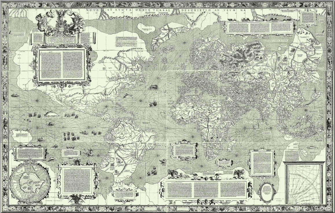
With the new release, customers also have the option to build Mercator imagery tiles for any 2-D maps they create with Google Earth Enterprise. Mercator is a commonly used conformal projection for viewing tiles in the browser. The new release allows customers to easily overlay their tiles on top of Google's basemap for a 2-dimensional mashup of their own internal data and Google's. (Thanks again to Gerardus Mercator and his great work on the Nova et Aucta Orbis Terrae Descriptio ad Usum Navigatium Emendate in 1569!)
We've also added support for Enterprise users to process their own sub-surface terrain data, also known as bathymetry – something we shared in the public Google Ocean launch in February 2009. Using the Earth API or latest Google Earth Enterprise client, you can now navigate below sea level to visualize that data in your organization's globe too.
Customers who want to access Google Earth Enterprise 3.2 can email enterprise-operations@google.
Posted by Dylan Lorimer, Product Manager, Google Earth Enterprise
Wednesday, June 3, 2009
Working with Google: Business tips to help you engage customers, monetize your site and work more efficiently
So, in this post, we thought we'd go through a quick summary of the wide range of Google products that can help you do business. We've grouped these tips into three buckets: methods to optimize your website, details about how your company info can get listed on Google properties and finally, ways to improve your business operations.
Your company’s internal search system can be just as good as Google’s – and just as easy to use. The Google Search Appliance (GSA) provides universal search for business, indexing all company content in a customizable way. The Google Search Appliance can search intranets, web servers, portals, file shares, databases, content management systems, and real-time data in business applications – and serve it up to employees in integrated, easy-to-navigate results. The new version of the GSA – GSA 6.0 – which just premiered yesterday, can now search billions of documents and provides rich customization features. Learn more
Posted by Debbie Leight, Google Apps team
Get timely updates on new features in Google Apps by subscribing to our RSS feed or email alerts.
Wednesday, May 6, 2009
GPS Fleet Tracking for Google Maps API Premier
Maps can be deployed within your organization to help your employees make fast, informed decisions – such as assessing the location and performance efficiency of your vehicles and other mobile assets. Tracking your assets on Google Maps became easier yesterday when FleetMatics announced that its GPS fleet tracking software is now integrated with Google Maps API Premier.
The FleetMatics solution provides real-time vehicle data, such as start/stop times and speed, to help its users efficiently dispatch to reduce vehicle mileage and downtime. With the addition of Google Maps, FleetMatics now offers the ability to visualize entire fleet locations and easily identify the closest vehicle to a given location.
FleetMatics customers can also use Google Maps to find driving directions and optimized routing information, including real-time traffic reports and nearby points of interest.
Thursday, April 16, 2009
New for Google Apps Admins: an online community
- The Admin community map – allows admins to easily see where their fellow community members are located; also highlights further information with a "click" on the marker.

- "Share your perspective " – uses Google Moderator to let admins easily add their own comments to posted topics, or vote on comments added by others. We've set this up to feature four topics at a time, so there's always something to talk about.
- "Stay Current " – the latest product information and posts to the Admin Help forum, so that Admins can see what's being discussed in Support
The Google Apps team hopes that this community adds value for admins, and we hope you'll take a look today.
Posted by Monali Narayanaswami, Google Apps team
Monday, February 2, 2009
Exploring new worlds with Google Earth Enterprise
We're happy to open up these new worlds of exploration to our Enterprise customers, with new releases of Google Earth Pro and Google Earth Enterprise also available today. This is a tremendous advance for organizations who work on -- or under -- the Seven Seas, or who have archives of historical photos and data that they'd like to make more accessible to their employees.
People who use Google Earth Pro, the workplace edition of Google Earth, will see the new oceanographic data, historical imagery, and other features through their connection to Google's public globe of satellite imagery, maps, terrain & 3D buildings. With today's release of the Google Earth Enterprise 5.0 client, customers can start to realize the benefits by layering their own private data on top of the Google-hosted Ocean or Historical Imagery via KML. Google's public data about the world's oceans and images from the past should give a glimmer of what's possible.
We're hard at work to allow Google Earth Enterprise customers to build their own Ocean or Historical Imagery for their private networks, in much the same way they today build their own Earth. This will enhance organizations' ability to build private globes displaying this information while ensuring that authorized users can visualize the data quickly and easily.
(That's Cape Fear under water, by the way.)The new Touring feature already works with private globes, allowing for simple creation of narrated tours of an area to share critical information with other Google Earth users. Touring compliments the Movie Maker capability, which lets users "fly through" Google Earth while capturing video that can be used in presentations, broadcasts, or on websites, available only in Google Earth Pro and the Google Earth Enterprise client.
And there's more. With this latest release, importing data from GPS devices is easier than ever. Customers will also find better ways to interact with their data. Pop-up windows for your data can now include fully compliant HTML and javascript, allowing organizations to provide their employees with richer context about the location they're viewing. And we've improved the startup speed and the performance of layers.
Existing customers who want to get started with the Google Earth Enterprise 5.0 client should contact Google customer support to access the download. Google Earth Pro customers will be prompted to upgrade the next time they start Google Earth. If you want to learn more about either product, drop us a line.
We hope you'll learn more about this announcement and bring the power of these new services to your organization, no matter where in the world (or the ocean!) you may be.
Posted by Bryan Atwood, Product Manager, Google Earth Enterprise